Saltar ao contido

Ficheiro:Egypt-12B-021 - Step Pyramid of Djoser.jpg

Os contidos da páxina non están dispoñibles noutras linguas.
Na Galipedia, a Wikipedia en galego.

Ficheiro orixinal (2.560 × 1.920 píxeles; tamaño do ficheiro: 4,07 MB; tipo MIME: image/jpeg)

Resumo

Descrición
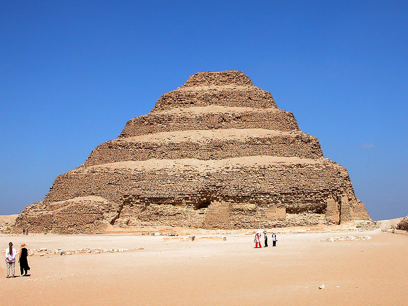
English: The Step Pyramid of Djoser is located at Saqqara, just south of Memphis. It started as a mastaba and was expanded six different times to six levels. A mastaba is a type of Ancient Egyptian tomb in the form of a flat-roofed, rectangular structure with outward sloping sides that marked the burial site of many eminent Egyptians of Egypt's ancient period.

This pyramid is the earliest stone pyramid in Egypt, thus became an important milestone in Ancient Egyptian Architecture that laid the basis for future and more advanced pyramids in Egypt. The Step Pyramid was already an attraction for many centuries. Evidence has shown that travelers and pilgrims have come to see the pyramid from as early as the Middle Kingdom Period (2040 to 1640 BC).

The Step Pyramid of Zoser was built approximately between 2649 to 2575 BC, during the 3rd Dynasty and under the rule of the pharaoh Zoser (or Djoser). The building was under the leadership of the pharaoh’s architect Imhotep. Because of Imhotep’s immense influence and contribution over Ancient Egyptian architecture, he was later deified and became god of the architects and doctors. Special permission from the Antiquities Inspectorate is needed to access the pyramid’s interiors.

Original height: 62.198 m (204 ft)

Base: 125.27 x 109.11 m (411 x 358 ft)
Data
Orixe

Egypt-12B-021 - Step Pyramid of Djoser

Autoría
Dennis G. Jarvis    wikidata:Q122977591
 
Dennis G. Jarvis
Nomes alternativos
pseudónimo: archer10; Archer10
Descrición fotógrafo
Control de autoridade
creator QS:P170,Q122977591
Please see the license conditions. Also, if used outside WMF projects, the photographer would appreciate if you'd let them know
Localización da cámara30° 04′ 08,73″ N, 31° 14′ 52,31″ L Kartographer map based on OpenStreetMap.Esta e outras imaxes na súa localización en: OpenStreetMapinfo

Licenza

w:gl:Creative Commons
recoñecemento compartir igual
Este ficheiro está licenciado baixo a licenza Creative Commons recoñecemento compartir igual 2.0 xenérico.
Vostede é libre de:
  • compartir – copiar, distribuír e difundir a obra
  • facer obras derivadas – adaptar a obra
Baixo as seguintes condicións:
  • recoñecemento – Debe indicar a debida atribución de autoría, fornecer unha ligazón á licenza e indicar se se realizaron cambios. Pode facer isto de calquera forma razoable, mais non nunha forma que indique que quen posúe a licenza apoia ou subscribe o seu uso da obra.
  • compartir igual – Se altera, transforma ou amplía este contido, debe publicar as súas contribucións baixo a mesma licenza ou outra compatible á orixinal.
A revisión desta imaxe, publicada orixinalmente no Flickr, levouna a cabo o administrador ou revisor File Upload Bot (Magnus Manske) o día March 13, 2012, e resolveu que nesa data estaba dispoñible no Flickr baixo a licenza citada enriba.

Pés de foto

Engade unha explicación dunha liña do que representa este ficheiro

Elementos retratados neste ficheiro

representa a

30°4'8.735"N, 31°14'52.307"E

0.00245821042281219272 segundo

13,7 milímetro

Historial do ficheiro

Prema nunha data/hora para ver o ficheiro tal e como estaba nese momento.

Data/HoraMiniaturaDimensiónsUsuarioComentario
actual13 de marzo de 2012 ás 13:28Miniatura da versión ás 13:28 do 13 de marzo de 20122.560 × 1.920 (4,07 MB)File Upload Bot (Magnus Manske){{Information |Description=PLEASE, no multi invitations in your comments. DO NOT FEEL YOU HAVE TO COMMENT.Thanks. DO NOT SEND ME E-MAIL REQUESTING ME TO LOOK AT A PICTURE, I RETURN ALL COMMENTS IF YOU COMMENT. The Step Pyramid of Djoser is located at ...

A seguinte páxina usa este ficheiro:

Uso global do ficheiro

Metadatos