
Ficheiro:End.of.Roman.rule.in.Britain.383.410.jpg

Ficheiro orixinal (2.582 × 3.220 píxeles; tamaño do ficheiro: 1.010 kB; tipo MIME: image/jpeg)
| Este ficheiro procede de Wikimedia Commons. A continuación móstrase a información da súa páxina de descrición. Commons é un repositorio libre de ficheiros multimedia. Pode contribuír alí cargando as súas imaxes. |
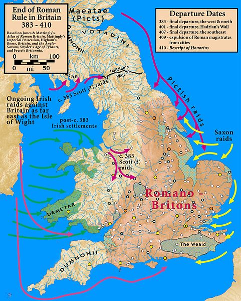
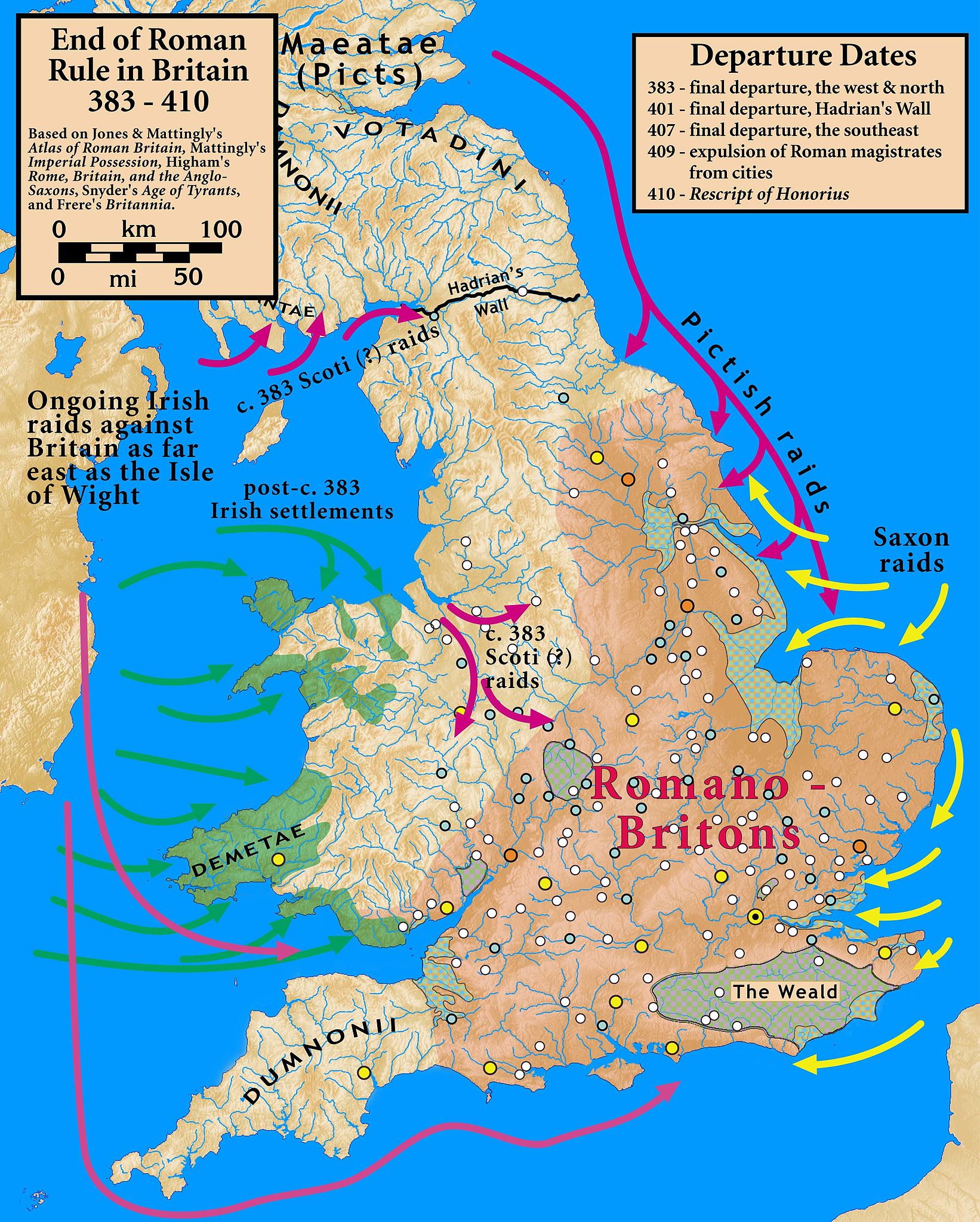
| Descrición | End of Roman Rule in Britain, 383–410 |
| Data | |
| Orixe |
Based on Jones & Mattingly's Atlas of Roman Britain (ISBN 978-1-84217-06700, 1990, reprinted 2007); Mattingly's Imperial Possession ( ISBN 978-0-140-14822-0, 2006); Higham's Rome, Britain, and the Anglo-Saxons (ISBN 1-85264-022-7, 1992); Frere's Britannia (ISBN 0-7102-1215-1, 1987); and Snyder's An Age of Tyrants (ISBN 978-0-631-22260-6) — the sources are cited in the image legend — Locations of towns (fortified and unfortified) are given on p. 156, with tribal civitates and coloniae specified on p. 154, of Atlas of Roman Britain. Specification of the Romanized regions of Britain are also from the Atlas, p. 151. The "Departure Dates" are found in the cited sources, and are generally known. The Pictish, Saxon, and Scoti raids are found in the cited sources, as is the date of the Irish settlements in Wales. Frere suggests (p. 355) that it was the Irish who sacked Wroxeter c. 383. The locations of the Irish settlements is from the locations of inscription stones given in File:Britain.Deisi.Laigin.jpg as of 2010-10-11, which cites its sources of information.
|
| Autoría | my work |
- Vostede é libre de:
- compartir – copiar, distribuír e difundir a obra
- facer obras derivadas – adaptar a obra
- Baixo as seguintes condicións:
- recoñecemento – Debe indicar a debida atribución de autoría, fornecer unha ligazón á licenza e indicar se se realizaron cambios. Pode facer isto de calquera forma razoable, mais non nunha forma que indique que quen posúe a licenza apoia ou subscribe o seu uso da obra.
- compartir igual – Se altera, transforma ou amplía este contido, debe publicar as súas contribucións baixo a mesma licenza ou outra compatible á orixinal.

|
Esta imaxe (ou todas as imaxes deste artigo ou categoría) deberían volverse crear como imaxes vectoriais SVG. Isto proporciona moitas vantaxes, véxase Commons:Media for cleanup (en inglés) para máis información. Se xa hai unha versión SVG desta imaxe dispoñible, por favor, cárguea en Commons. Tras subila, substitúa este modelo polo modelo {{vector version available|novo nome da imaxe.svg}} nesta imaxe.
|


Historial do ficheiro
Prema nunha data/hora para ver o ficheiro tal e como estaba nese momento.
| Data/Hora | Miniatura | Dimensións | Usuario | Comentario | |
|---|---|---|---|---|---|
| actual | 18 de outubro de 2010 ás 20:07 | | 2.582 × 3.220 (1.010 kB) | Notuncurious | {{Information |Description=End of Roman Rule in Britain, 383–410 |Source=Based on Jones & Mattingly's ''Atlas of Roman Britain'' (ISBN 978-1-84217-06700, 1990, reprinted 2007); Mattingly's ''Imperial Possession'' ( ISBN 978-0-140-14822-0, 2006); Hig |
Uso do ficheiro
A seguinte páxina usa este ficheiro:
Uso global do ficheiro
Os seguintes wikis empregan esta imaxe:
- Uso en ar.wikipedia.org
- Uso en ast.wikipedia.org
- Uso en be.wikipedia.org
- Uso en bn.wikipedia.org
- Uso en ca.wikipedia.org
- Uso en da.wikipedia.org
- Uso en en.wikipedia.org
- Uso en es.wikipedia.org
- Uso en et.wikipedia.org
- Uso en fa.wikipedia.org
- Uso en fr.wikipedia.org
- Uso en hr.wikipedia.org
- Uso en it.wikipedia.org
- Uso en ja.wikipedia.org
- Uso en lfn.wikipedia.org
- Uso en pnb.wikipedia.org
- Uso en pt.wikipedia.org
- Uso en ro.wikipedia.org
- Uso en ru.wikipedia.org
- Uso en sh.wikipedia.org
- Uso en sr.wikipedia.org
- Uso en tr.wikipedia.org
- Uso en ur.wikipedia.org
- Uso en www.wikidata.org
- Uso en zh.wikipedia.org