
Ficheiro:Noord-Brabant position.svg

Tamaño desta vista previa en PNG do ficheiro en formato SVG: 200 × 236 píxeles. Outras resolucións: 203 × 240 píxeles | 407 × 480 píxeles | 651 × 768 píxeles | 868 × 1.024 píxeles | 1.736 × 2.048 píxeles.
Ficheiro orixinal (ficheiro SVG; resolución de 200 × 236 píxeles; tamaño do ficheiro: 158 kB)
| Este ficheiro procede de Wikimedia Commons. A continuación móstrase a información da súa páxina de descrición. Commons é un repositorio libre de ficheiros multimedia. Pode contribuír alí cargando as súas imaxes. |
Resumo
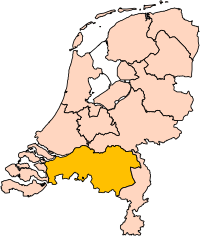
| Descrición | Location of the province of Noord-Brabant (North Brabant) in the Netherlands. |
| Data | |
| Orixe | Own work, based on freely available GIS data |
| Autoría | User:Mtcv |
| Licenza (Reuso deste ficheiro) |
Data: attribution required; my work: PD |
| Outras versións | I attempted to make an svg version of Image:Noord Brabant-Position.png (with less simplified boundaries) |
Clickable version

Licenza

|
O propietario dos dereitos de autor deste ficheiro, Centraal Bureau voor de Statistiek, permite que calquera poida usalo para calquera propósito, sempre e cando se lle recoñeza a autoría a quen cede os dereitos. A redistribución, edición, uso comercial e calquera outro tipo de uso están permitidos. |
Recoñecemento:
|
| Anotacións | Esta imaxe ten anotacións: Olle as anotacións en Commons |


Historial do ficheiro
Prema nunha data/hora para ver o ficheiro tal e como estaba nese momento.
| Data/Hora | Miniatura | Dimensións | Usuario | Comentario | |
|---|---|---|---|---|---|
| actual | 2 de marzo de 2019 ás 17:20 | | 200 × 236 (158 kB) | Thayts | update |
| 3 de outubro de 2006 ás 00:49 |  | 200 × 236 (158 kB) | Mtcv | {{Information| |Description=Location of the province of Noord-Holland (North Holland) in the Netherlands. |Source=Own work, based on freely available GIS data |Date=2006-10-03 |Author=User:Mtcv |Permission=Data: attribution required; my work: PD |othe |
Uso do ficheiro
Non hai páxinas que usen este ficheiro.
Uso global do ficheiro
Os seguintes wikis empregan esta imaxe:
- Uso en ar.wikipedia.org
- شمال بربنت
- آيندهوفن
- بريدا
- بارله ناساو
- تيلبورخ
- سيرتوخيمبوس
- قالب:بلديات شمال برابنت
- آلبورخ
- ألفن- كام
- أستن
- بيرخ آيك
- فيلدهوفن
- بيرخن أوب زووم
- بيرنهيزه
- بيست (هولندا)
- بلادل
- بوكل
- بوكسمير
- بوكستل
- كرانندونك
- كاوك
- دورنه
- دونجن
- دريميلين
- إيرسل
- إيتن- لور
- خيرتراودنبيرخ
- خيلدروب- ميرلو
- خيميرت- باكل
- خيلزه آن راين
- خورلا
- خرافه (هولندا)
- هارن (شمال برابنت)
- هالدربيرخه
- هيزه- لينده
- هيلموند
- هوسدن
- هيلفارينبيك
- لاربيك
- لانديرد
- لوب أوب زند
- مل آن سينت هوبرت
- موردايك
- نونن (خيرفن آن نيدرفيتن)
- أويرشخوت
- أويسترفايك
- أوسترهاوت
- أوس (هولندا)
- روسل- دي ميردن
- روسيندال
Ollar o uso global deste ficheiro.